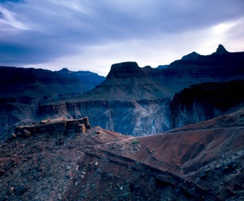
(above) The South Kaibab trail traces its path downward towards the Colorado River. This picture was taken at about two thirds of the way down. (Previous Page) The Black Bridge serves hikers and mules above the Colorado River.We begin as a group on the Grand Canyon's South Rim Kaibab Trail at 5:15am. Our goal is to travel 21 miles and exit at the North Rim by sunset. We travel lightly, each carrying about 100 ounces of water between re-fill stops, fruits, a sandwich (or two), dried liquid mix supplements, spare socks, sunglasses, lotion, and a few other accessories.
We descend rapidly from our starting point at 7,260 feet above sea level, enjoying the dramatic views from the South Kaibab Trail. After two hours, the Colorado River can be heard rushing below. After almost three hours, we reach 2,400 feet above sea level and enter a tunnel that emerges onto the Black Bridge. Standing on the bridge is truly fantastic, as you watch the Colorado River race below you. The air is still cool, the canyon walls are beginning to light up as the sun climbs, and no other sound can be heard but the river below.
We move on and shortly reach Phantom Ranch at 8:30am. We have covered 7 of our 21 miles, mostly by hiking downhill. The vegetation has changed from high desert Juniper Trees to Cactus and shrubs. We enjoy a short break, regain our strength with light snacks, re-fill our water supplies, and adjust our gear.
The next portion of the trip continues North into an area called "The Box". For the next five miles, the box's narrow canyon only reveals a narrow strip of sky above. The walls rise over 2,000 feet straight up on either side of us accompanied by a stream (Bright Angel Creek) that runs parallel to our trail. The rock in this area is called Vishnu Schist, and was formed over 1 billion years ago. This rock formation surrounding us is incredibly patterned and detailed, revealing ages of incredible pressure placed upon it. The day begins to warm up, but for now, the box provides us shade.
As we approach 12 miles into our hike, we reach what we call "Heartbreak Hill". I once asked what does the trail do between the North and South Rims as you traverse the Grand Canyon and was told (with a laugh) that the hike is never flat - the trail is always doing something, either going up, or going down. At Heartbreak hill, it goes up. Heartbreak isn't that tall, it's just that you climb for a while, reach the top and realize the trail goes right back down again. Heartbreak hill gives us a taste of the significant uphill work that still awaits us. The sun is now unmerciful and exposed, and temperatures rise to the 90's. In my experience, Heartbreak hill is a good predictor on our relative fitness levels, and how well we will fare as we approach the final climb-out.
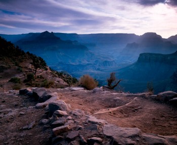
(Above) The sun rises next to the South Kaibab Trail.